Firing up some research!
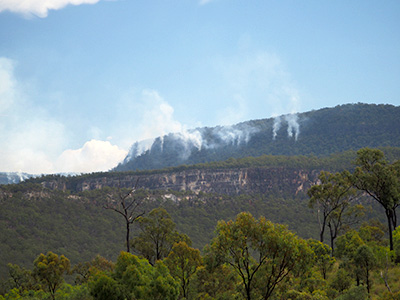
As Carnarvon Gorge’s most experienced field guide, I have long wished for the opportunity to answer some of the questions generated in my 20+ years of wandering around this landscape. In 2021 that wish came true and I commenced a PhD researching biodiversity patterns in the Gorge using automated acoustic recorders. However, like most PhD projects, things have not always gone to plan. From Dingoes munching on coverboards, to horses using camera traps as butt-scratchers and playthings, there have been a few curveballs to deal with. The latest has been a mischievous planned burn (pictured above) implemented in early April.
Planned Burn
Planned burns are nothing new for Carnarvon Gorge, which has a long history of fire management. They are carried out to keep forest floor fuel levels below manageable thresholds, to lower the incidence and impact of wildfire, to promote biodiversity, and to keep visitors as safe as possible. This burn was carried out on the 6th of April using incendiaries launched from a helicopter under the guidance of National Park staff. You can see the individual plumes coming up from the forest floor where the incendiaries have been dropped in the above photograph.
Current fire management is implemented by an experienced team, including Lindie, the Ranger in Charge at Carnarvon Gorge. She was in the helicopter directing the bombardier (yes, that’s the actual job title) where to release the little balls of fiery goodness from the contraption hanging out the chopper door.
Lindie also consistently volunteers her free time to help with my research. For example, prior to this burn being carried out, she lugged a rake-hoe up to the four shelf country sites above the cliffline to help prep them for the burn. These sites are spread across four kilometres, from above Boolimba Bluff to above Wards Canyon, and are separated by some rugged terrain where all the side-gorges terminate at the bottom of the basalt plateau. It was no mean feat getting to all of them in a day.
,
The burn does some planning of its own...
The burn was implemented on April 6th and commenced according to plan. However, the weather didn’t play ball and the rain in the forecast turned out to be quite patchy. It doused the area around the mouth of the Gorge a few nights after the burn commenced, but did not touch the majority of the country alight to the west.
As a result, the fire was able to make its way out of the area Rangers wanted to burn up to the Consuelo Tableland. However, this area was scheduled for a planned burn later in 2023 so that was not altogether a bad thing, apart from the fact that it was burning early.
Unfortunately for me, the project has four sites up on the Tableland. They had not yet been prepped for fire as we weren’t expecting it to get up that high. Satellite data showed hotspots tracking toward the westernmost Consuelo site, albeit slowly. I had to dip into my equanimity stash while we figured out what, if anything, could be done, and whether it could be done safely.
Lindie to the rescue
First hurdle: my project’s risk management had not foreseen a desire to move toward an active fire front in the hope of saving project infrastructure. How was I going to get around that?
At first, I was thinking I would have to head up at night when the fire front was least active and therefore safest. However, that would be quite a bushwalking challenge. Accessing the sites on the high country involves gaining ~600 meters in height over around 6 kilometres, the last two of which are off any tracks. Then, to get to the westernmost site, you traverse a further 4 km through waist high grass with no tracks to speak of.
Doing this on my Pat Malone by head torch overnight was a daunting prospect. My second hurdle was my experience with wildfire, or lack thereof. I’ve worked with fire on cattle properties, but always off firebreaks and in the company of experienced others. Understandably, my supervisors and I were not leaping at the chance of heading solo towards the mobile barbecue happening at the top of a landscape with limited opportunities to get out of the way safely. The Consuelo Tableland is edged by basalt cliffs 30-40 metres high with only a handful of known pathways down.
After watching the fire from the Gorge floor, and sending the Rangers at Mt Moffatt out to see what was happening on the Tableland first hand, Lindie grew confident that the fire was slow moving enough not to be a threat to life and limb – as long as she was along to take charge. My team was confident enough in her skills and experience to accept the recommendation and the help. So off Lindie and I toddled at 3 am on April 13th with the plan to bury the recorders and trail cameras at each of the sites we could safely reach. According to the satellite data, the fire was within a kilometre of the westernmost of the Consuelo research sites while all others be next to zero risk.
Nearly, but not quite.
We crested the Consuelo Tableland just after sunrise and made our way to the first recorder. To our suprise, the fire had made it to within 50 metres of our gear and then inexplicably stopped.
None of the fire data from satellite observations had recorded this little patch, and it had clearly been inactive for some time. Later, I sifted through the recordings collected from this site and discovered that the fire had reached the Tableland here a few days after being lit. Just after you could clearly hear fire in the recording it was pulled up by a five minute shower of rain at 2 am in the morning. Phew!
Bucking the regional trend.
Lindie and I were ready for anything as we headed towards the remaining three sites. However, we saw no evidence of fire for the rest of the day and merrily got on with the job at hand. While many Queenslanders spend a fair bit of time digging wealth out of the ground, we went the other way…

With nothing more than a trowel, we buried each of the recorders and the wildlife cameras in the rich basalt soil, dutifully marking each with an ‘X’ on the GPS for future retrieval. As of the time of writing, there really is buried treasure underneath those markers.
Back to the Shelves.
Most of the fire was extinguished by 1.2 mm of rain that fell around the 16th of April. Only a small patch east of Boolimba Bluff below Clematis Ridge survived. This allowed me to head back up to the shelf country above the cliffs to start getting all the sites back into action. While the recorders remained operational, the wildlife cameras were brought in.

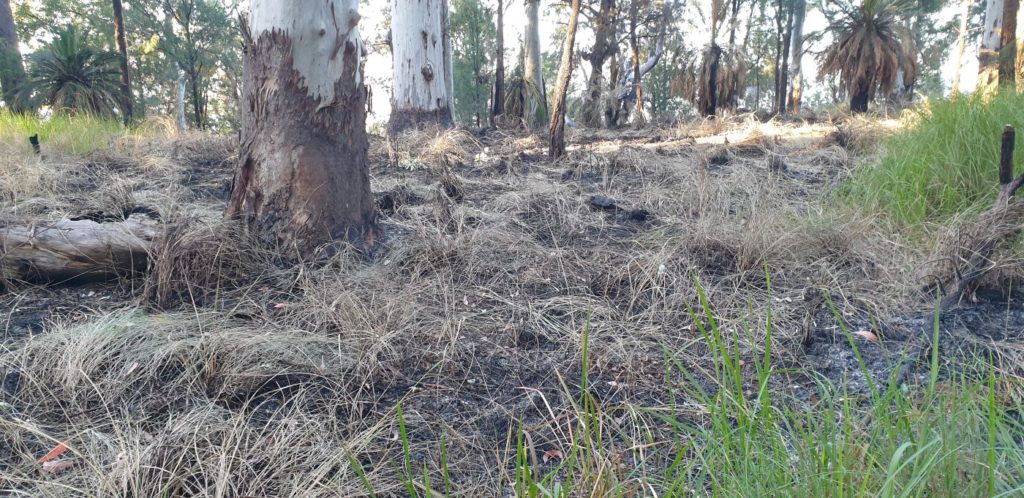
Climbing up one of the gullies west of Wards Canyon, I got to within 2km of my target site before reaching burnt country. Fire struggles to travel down a slope, which is probably what pulled it up (left).
The fire burnt the ground layer well, but had not disturbed the mid layer much and regrowth was already well underway. These are grass trees reshooting (right).

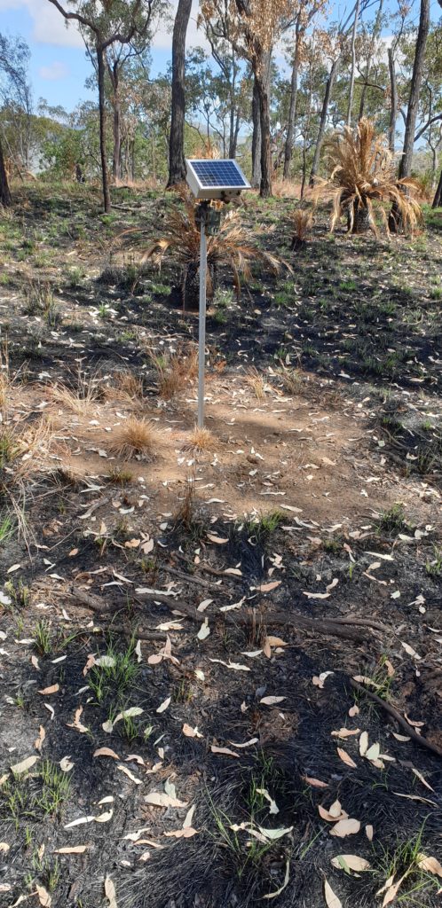
Lindie’s rake-hoe skills proved up to the task and the recorder stood proudly in it’s unburnt patch. However, the fire had enough radiant heat to partially melt the straps securing the wildlife cameras to the star picket. It had not damaged the cameras themselves, luckily. We’ll have to deal with them differently in the future to ensure they survive unscathed.
And now it’s time to get back to the remaining 7 sites in need of recommissioning. It’ll be hard physical work, but the upside is I’ll be out and about in some of the least travelled sections of Carnarvon Gorge and the results of this project will help us get better and better at knowing how the Gorge works and, thus, how to manage it better into the future.
P.S.: One last silver lining! I won’t be pushing through waist high kangaroo grass getting those sites back into action. Thanks, Lindie!!
“Absolutely thrilled with the depth of insights shared in this article! Your dedication to providing valuable information on Carnarvon Gorge and its ecological significance is truly commendable. Thank you for firing up our research and sparking a newfound appreciation for this stunning natural wonder!”
Had a wonderful full day guided walk through the Gorge with Simon on Tuesday 12 August this year. His depth of knowledge about the flora, fauna and aboriginal history of the area is just amazing. And his way of sharing his knowledge kept our party of 8 interested all day long. We met at 7 in the morning and all of a sudden it was nearly 5 o’clock! Thank you Simon. We are all richer from the experience. Kind regards, Karl